Track and time this hike using a mobile device!
TRACK AND TIME YOUR HIKE
Trans Canada Trail North Burnaby
 Directions to Trans Canada Trail North Burnaby
 Download offline KML trail map of Trans Canada Trail North Burnaby

Add your own photos
Second Narrows Montrose Park, Burnaby
49.292233, -123.025667
7°c Light Rain Humidity: 85% Sunset: 7:41 pm
Track and hike this trail on your mobile device!
Total Distance
(One Direction)
(One Direction)
Total Ascent
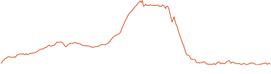
Elevation Profile
Trail Description
Connects to the Vancouver arm of the Trans Canada Trail. Great views West towards Vancouver from Burnaby Mountain.
Photos of Trans Canada Trail North Burnaby
There are no photos of this trail added yet. Add your own photos
There are no photos of this trail added yet.
Download Free KML Trail Map for Trans Canada Trail North Burnaby
 Trans Canada Trail North Burnaby is equipped with a free downloadable offline trail map that can used in Google Earth, Google Maps/KML enabled cell-phone or in a GPS device.
Download KML trail map
Trans Canada Trail North Burnaby is equipped with a free downloadable offline trail map that can used in Google Earth, Google Maps/KML enabled cell-phone or in a GPS device.
Download KML trail map
Trails near Trans Canada Trail North Burnaby
Lynn Valley Link Trail 3.2 km away
Hyannis Trail 4.7 km away
Old Buck Trailhead 5.2 km away
Powerline Trail 5.5 km away
Bridal Path Trail 5.7 km away
Top Trail Times
| # | Hiker | Date | Start Time | Duration |
Comments